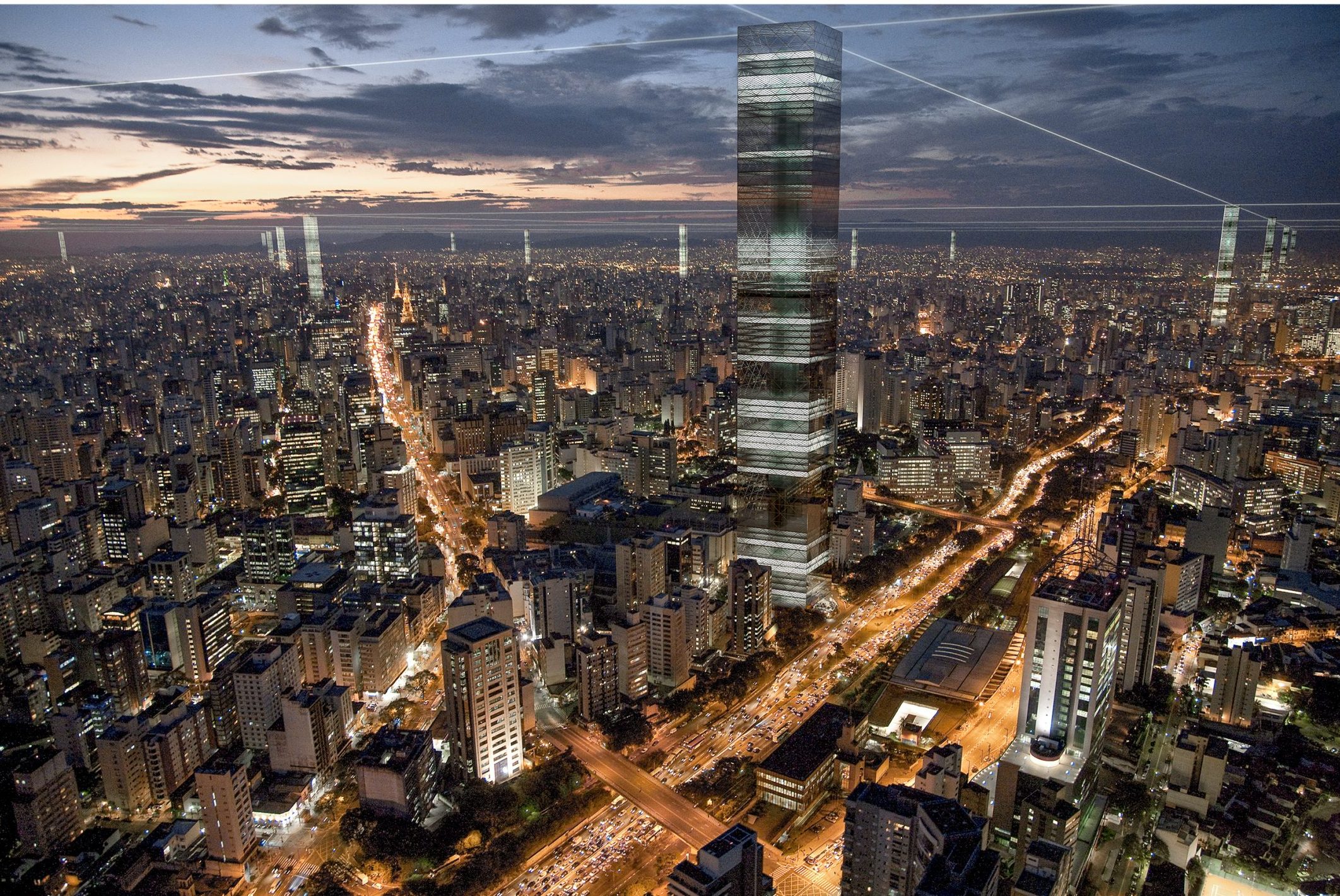
If we could describe it as a single entity, there would be nothing created by humans larger than the city. Not just in terms of its physical size, but also because of its immense capacity to generate diversity, complexity, and meaning. One of the consequences of these dimensions and the speed of its transformations is the impossibility of fully grasping or defining it, and therefore, the impossibility of conceiving or designing the city. Architecture has been dedicated to designing specific and isolated spaces—buildings, squares, stations—in which thoughts about the city are condensed, but which do not address its entirety. In metropolises, the few interventions that consider the whole city are the networks and systems of technical services—such as transportation, water distribution, and data. They spread across the territory, connecting all its points, and are in constant transformation.
Our proposal is an essay that combines a design of the city’s form with the logic of networks, providing material visibility to the territory without diminishing the transformative and flexible potential inherent in the contemporary city. Although speculative, this essay is not impossible to achieve either technically or commercially.
Proposal
A regular orthogonal grid of 4.25 km x 4.25 km superimposed on the city of São Paulo will define, at the intersections of its axes, points of activity concentration. At these points, large towers will be constructed, with flexible use and form, adapted to the desires, history, or vocation of the region in which they are located.
Form
In addition to the distribution grid of the buildings, the other fixed component of this network will be the height of the towers. All of them will be 1,135 meters above sea level, the elevation of the top of Pico do Jaraguá, the highest point and one of the most prominent geographic landmarks in the São Paulo landscape. At the top of each tower, there will be an observation deck, all aligned at the same elevation, from which it will be possible to view the regular grid formed by these points and the relationship between this virtual plane and the undulations of the city’s topography. Once the top level is fixed, each tower will have a different height depending on its location. A tower in an area like Avenida Paulista, elevated compared to the river valleys, 720 meters above sea level, will have fewer floors than a tower in Pinheiros or Parque Dom Pedro. Thus, in addition to connecting all neighborhoods through long-distance visibility, each location will have a different tower. The horizontal plane formed by the visual connection between the tops of the towers reinforces and reveals the perception of each place’s position relative to the topographical configuration of the land and to other places in the city, creating a physical reference that São Paulo lacks.


